SEDONA
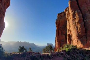
Nature is the main attraction in Sedona.
A hiker’s paradise, offering trails that cater to all skill levels amidst its iconic red rock landscapes. With its unique combination of distinctive red rocks, stone arches, hidden caves, ancient ruins, a whopping 200-plus trails, and perpetual sunshine, it’s hard to top Sedona as an Arizona hiking destination.
SAMPLE ITINERARY
Day 1
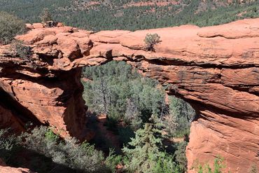
Devil’s Bridge Via Mescal Trail
Distance: ~4 miles (7km), Elevation Gain: 528′ (161m)
Your trip begins with ESC meeting you at either the Flagstaff or Phoenix airport. Our drive to Sedona, part of the Coconino National Forest, will see us driving through Oak Creek Village into Sedona or down through Oak Creek Canyon. Both directions will be through beautiful and stunning landscapes. Our stay for the entirety of the trip is at the Southwest Inn, located just minutes from Sedona’s top trails. Depending on your arrival time, we will drive to Devil’s Bridge via the Mescal Trail for a short, awe-inspiring hike to help get the kinks out after your flight. Afterwards we will check in to our rooms then head into downtown for our first of five group dinners.
Day 2
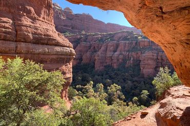
Boynton Canyon, Red Rock – Secret Wilderness:
Distance: ~8 miles (13km), Elevation Gain: 964′ (294m)
We start our day with an early breakfast at the Coffee Pot Restaurant, then head to Boynton Canyon, 15 minutes away, to begin our first hike. Home to the famous ‘secret’ Subway Cave and an especially unique energy vortex, it’s no surprise the Boynton Canyon Trail is one of the most popular hikes in Sedona. A locals-only secret just a few years ago, the Subway Cave in Sedona is now ultra famous and one of the most sought-after photo ops in the Southwest. Rightfully so, as this ‘hidden’ keyhole-shaped cave just off the Boynton Canyon trail packs a tremendous punch. In a relatively short, moderate hike, you will have the opportunity to not only explore the Subway Cave but also experience one of Sedona’s revered energy vortexes and see ancient cliff dwellings. Along the way, of course, you’ll also enjoy plenty of that iconic red rock scenery! On our return home from a wonderful day on the trail, we will have time to relax the remainder of the afternoon before dinner.
Day 3
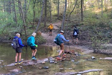
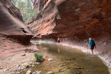
West Fork Oak Creek Canyon:
Distance: ~9 miles (15km), Elevation Gain: 564′ (172m)
After an early coffee and food on-the-go we head about 20 minutes north to the West Fork of Oak Creek Canyon. The best trail in the Sedona area is along the lower end of the West Fork of Oak Creek, a permanent though relatively shallow stream, depending on the season, that flows through a deep, forested canyon, narrow in places, with multiple eroded rock formations and plentiful wildlife. Hiking up Oak Creek's west fork offers one of the best outdoor experiences in Sedona, an area already known as a hiker's paradise. The steep canyon walls and the shade of trees make this a perfect trail to avoid the heat of the Arizona sun. We will follow the creek upstream along pleasant sandy trails and thirteen separate stream crossings and enjoy the imposing views of the canyon walls towering above. Unless the waters are high, the crossings are relatively easy, and the elevation gain on this trail is slight. The trail ends where the canyon walls close in on you, and there's nowhere else to go without getting your feet wet. Most hikers tend to stop here to enjoy lunch or a snack. We, however, being suitably equipped with water shoes or sandals, will continue to wade upstream for another quarter of a mile or so to enjoy the incredible views, make the most of the photo opportunities, and marvel at how the water has etched away at the rock over the millennia. After our hike, we will stop in Sedona for lunch and to support local businesses before returning home to relax before dinner.
Day 4
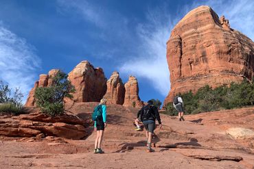
Cathedral Rock:
Distance: ~5 miles (8km), Elevation Gain: 1548′ (472m)
Today we head about 20 minutes east to Cathedral Rock Trail. As soon as you see it, you will know that the name fits perfectly. Cathedral Rock is a skyline dominating sandstone butte in the center of Sedona and it’s one of the most photographed natural landmarks in Arizona. A challenging yet beautiful trail that offers great views of the unique natural rock formations in the area. A popular choice for hikers of all ages, we have another early morning to beat the crowds and summit in time to hopefully watch a stunning sunrise erupt over Sedona. To reach the top, we will scramble up various heavily traveled rocks that can be very slippery. The hike to the top can take between half an hour to an hour each way from the trailhead. The views from the top are worth the climb. After our hike we will go to breakfast/lunch before heading across town for our hike to the Birthing Cave.
Birthing Cave:
Distance: ~2 miles (3km), Elevation Gain: 270 feet (82m)
The name “Birthing Cave” comes from the Indigenous communities, including the Hopi tribe, who traditionally used this cave as a sacred space for childbirth. Pregnant women would climb into the cave, sit, and pray before giving birth, believing that the cave’s energy supported new life. This short but beautiful trail leads to a stunning cave that offers fantastic views at the end. Although the hike is rated as moderate, don’t underestimate its length. The last section of the trail is steep and requires some scrambling. However, once we reach the cave, the effort is rewarded with a breathtaking view. After our hike we will head home to clean up, relax or head into town for an afternoon of wandering city center before dinner.
Day 5
Wilson Mountain Peak Trail:
Distance: 11 miles (18km), Elevation Gain: 2490′ (759m)
Today, after an early breakfast, we head north again towards Oak Creek for our last hike of the trip. North Wilson Mountain Peak Trail is a stunning path that leads to Wilson Mountain Peak. Although the trail includes several rocky and steep parts that make the hike challenging, the stunning views of the valley and nearby mountains make it all worth it. After we reach the mesa, we will head north to enjoy the view of Oak Creek Canyon and then back south across the mesa to eat lunch and enjoy the beautiful views of Sedona. On our return to Sedona, we will stop for coffee, ice cream, etc. before returning home to relax for the remainder of the afternoon before dinner.
Day 6
Breakfast:
We will enjoy our last breakfast at The Coffee Pot Restaurant before heading out. Depending on time and departure locations, we head into Flagstaff with a stop at Late for the Train Coffee Shop, for a quick fuel up and another wonderful drive back through Coconino National Forest to where your trip began in Phoenix, Arizona. As we descend from the Mogollon Rim into northern most part of the Sonoran Desert, our thoughts may be of our days hiking and the incredible beauty of Sedona.
Please schedule all homebound flights for after 2 pm.
AVAILABLE DATES: TBD
$4570 person
Deposit $1000
Duration: 6 Days, 5 nights
Length: 5 hikes: 70 miles (113km)
Intensity: Level 2-4
Begins In: Phoenix/Flagstaff
Ends In: Phoenix/Flagstaff
Airport:
Sky Harbor International (PHX)
Flagstaff Pulliam Airport (FLG)
Location: Coconino National Forest
All-Inclusive Multi-Day Trip Experiences:
No hidden costs. No last-minute surprises. Just an all-inclusive adventure designed for effortless enjoyment.
Other than a tip for your guide team, your travel to & from and personal clothing & gear, our trips are essentially all-inclusive experiences. We provide all transportation from pickup to drop off and much more.
Accomodations:
We use only the best available hotels or lodges in the area we are traveling. They are comfortable and conveniently located.
Food Menus:
You can rest assured we’ll do our level best to make certain that your dietary needs are met. Beyond the excellent restaurants we visit, we strive to ensure options for vegetarian, vegan, and many allergy-restricted diets are available. However, based on where we may be visiting, we cannot always provide the same diversity or sophistication for restricted diets as you may be expecting.
ESC Outside does our best to support local business’s. We are always on the lookout for great coffee shops; and our dining arrangements are the best of the areas we are visiting. Please call us with any questions or concerns.
What's Included with our Multi-Day Trips:
- Professional guide service at a 3:1 guest-to-guide ratio or better.
- All meals – Breakfast, Lunch, Dinner, Snacks
- Ground transportation from arrival to departure at the closest International or Regional Airport to our destination.
- Lodging every night for the length of the trip.
- All activities listed on the itinerary.
- 1 year membership to American Alpine Club
What's NOT Included with our Multi-Day Trips:
- Lodging prior to and after your trip.
- Personal gear (packs, rain gear, etc.).
- Trip cancellation/interruption insurance.
- Personal alcoholic beverages, outside of dinner.
- Guide gratuities (generally 5-10% of the trip cost is suggested)
These areas are some of the most popular in Sedona, and some of the most sought after by hikers. It is important to follow the principles of "leave no trace" to help protect cultural sites. The Archaeological Resources Protection Act of 1979 prohibits the removal of artifacts, climbing on or sitting against ruin walls, and defacing archaeological sites on state, federal, and Native American lands.