Mount Whitney, CA
Whitney is a challenging and an incredible accomplishment.
At 14,505 (4421m) feet, Mt Whitney is the highest point in the lower 48 and is one of those rare high peaks that you can hike to, depending on the weather conditions, without any mountaineering skills. Native American tribes, including the Paiute, have inhabited the area for thousands of years, referring to the mountain as "Tûkwi." The “Whitney Trail,” built in 1904, is on every hiker's bucket list and the most popular route on the mountain. Most people tackle Mt Whitney as a 21.5mile round-trip day hike. Its long, very doable, with the proper training, and comes with a great sense of accomplishment when you finish.
SAMPLE ITINERARY
Day 1
Los Angeles to Lone Pine, CA:
Distance: ~214miles (344km), Elevation Gain: 3,575′ (1090m)
Your trip begins in Los Angeles CA, the city with endless possibilities. Luckily, we are only in the “City of Angels” for a very short time. We make our escape Northeast from LA with a 4hr drive past Angeles National Forest and Mojave, CA before heading north to the eastern side of the Sierras. As the mountains begin to continually grow bigger, we arrive in the town of Lone Pine, home for the next four days. Lone Pine is your gateway to Mt. Whitney & Death Valley! One thing that makes Lone Pine so special and unique is that both the HIGHEST & LOWEST elevations in the lower 48 states are each within a 1 HOUR drive! Our stay for the entirety of our trip is at the Portel Motel. Depending on our arrival time, the remainder of the afternoon is yours to relax after your travels or explore the town. As our day turns to evening, we take a short walk for the first of three group dinners.
Day 2
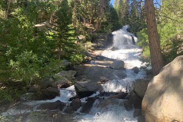
Mt Whitney Portal to Lone Pine Lake
Distance: ~7miles (11km), Elevation Gain: 2,000′ (610m)
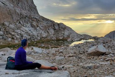
We start our day with an early breakfast then head up to Whitney Portal, 11 miles away, to begin our first hike and acclimate. Lone Pine Lake is a stunning alpine lake that is a 7mile out-and-back trail from Whitney Portal. Within the first 3.5 miles, the route gains more than 2,000 feet in elevation before reaching Lone Pine Lake. The scenery is spectacular and looks as if the water just pours off the edge of the cliff. We will return home to organize & prepare our gear, have an early dinner, relax and get some sleep before a very early start of our “BIG” Hike.
Day 3
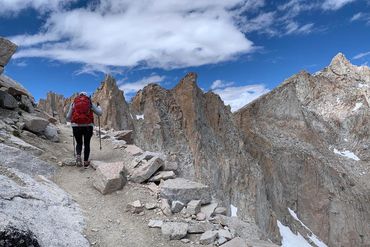
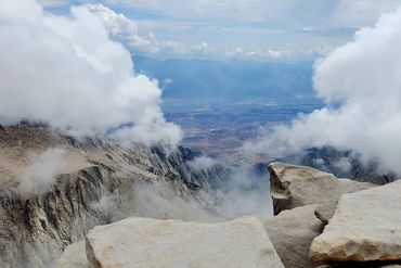
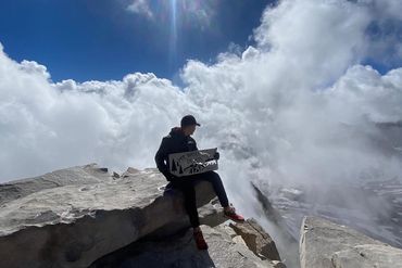
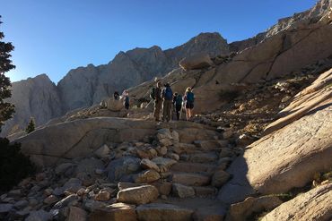
Mt. Whitney: Sequoia National Park, Inyo National Forest
Distance: ~22miles (35km), Elevation Gain: 6,663′ (8127m)
This strenuous out-and-back trail leads past rocky switchbacks, sheer cliffs, and flowing waterfalls to the summit of Mt. Whitney, the highest point in the contiguous United States. Reaching the summit of Whitney is challenging and an incredible accomplishment. Given the technical nature of the route and the length of the trail, we will have a very early start, around 2am, for the long (Expect to hike 12 to 16 hours to the summit and back) day ahead. The trail averages 550' of elevation gain per mile and will pass several lakes along the way. At 6 miles from the trailhead, Trail Camp (12,039'/3670m), sits at the base of the infamous "97 switchbacks." Once we’ve climbed the “97 switchbacks”, we will meet up with the John Muir Trail and follow the ridgeline to the summit. While challenging, the ascent up Whitney is an unforgettable experience and the rewards are a panoramic, jaw-dropping view that stretches as far as the eye can see. One thing to remember is... we still have 11.5 miles of hiking to get back to the trailhead. On our return home, depending on time, we will enjoy a celebratory dinner, a well-earned night’s sleep as well as the joy of having achieved a true hiking milestone.
Day 4
Breakfast & Lunch Included:
We enjoy our last breakfast together before heading back to Los Angeles, stopping in Pacific Palisades for lunch to celebrate our accomplishment. After lunch we head to Los Angeles International Airport to say our goodbye’s as your trip ends where it began in Los Angeles CA, the city with endless possibilities.
Please schedule all homebound flights for after 2 pm.
Hiking the Mt. Whitney Trail is a non-technical, when it is free of snow, strenuous hike and the effects of the high altitude can become intense in route to the summit. Many hikers suffer from altitude sickness and are forced to turn around. It is highly recommended that you spend as much time as possible hiking to elevation and given the opportunity, acclimating before attempting to hike to the summit. While it may “only” be 11.5 miles to the top, you still must hike the 11.5 miles back down to the trailhead. The trail is usually snow-free from July to late September. However, to travel as safe as possible when snow or ice is on the mountain, winter mountaineering skills and equipment are necessary.
Please use this SAR PDF document to help you prepare:
https://inyosar.com/wp-content/uploads/2020/02/PSAR-2020.pdf
AVAILABLE DATES: TBD
$3195 person
Deposit $1000
Duration: 4 Days, 3 nights
Length: 2 hikes: 29 miles (42km)
Elevation Gain: 8663' (8737m)
Intensity: Level 5+
Begins In: Los Angeles CA
Ends In: Los Angeles CA
Airports:
Los Angeles International (LAX)
John Wayne (SNA)
Locations:
Inyo National Forest,
Sequoia National Park
All-Inclusive Multi-Day Trip Experiences:
No hidden costs. No last-minute surprises. Just an all-inclusive adventure designed for effortless enjoyment.
Other than a tip for your guide team, your travel to & from and personal clothing & gear, our trips are essentially all-inclusive experiences. We provide all transportation from pickup to drop off and much more.
Accomodations:
We use only the best available hotels or lodges in the area we are traveling. They are comfortable and conveniently located.
Food Menus:
You can rest assured we’ll do our level best to make certain that your dietary needs are met. Beyond the excellent restaurants we visit, we strive to ensure options for vegetarian, vegan, and many allergy-restricted diets are available. However, based on where we may be visiting, we cannot always provide the same diversity or sophistication for restricted diets as you may be expecting.
ESC Outside does our best to support local business’s. We are always on the lookout for great coffee shops; and our dining arrangements are the best of the areas we are visiting. Please call us with any questions or concerns.
What's Included with our Multi-Day Trips:
- Professional guide service at a 3:1 guest-to-guide ratio or better.
- All meals – Breakfast, Lunch, Dinner, Snacks
- Ground transportation from arrival to departure at the closest International or Regional Airport to our destination.
- Lodging every night for the length of the trip.
- All activities listed on the itinerary.
- 1 year membership to American Alpine Club
What's NOT Included with our Multi-Day Trips:
- Lodging prior to and after your trip.
- Personal gear (packs, rain gear, etc.).
- Trip cancellation/interruption insurance.
- Personal alcoholic beverages, outside of dinner.
- Guide gratuities (generally 5-10% of the trip cost is suggested)